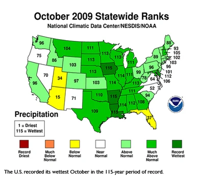
Preliminary data from the Nat’l. Oceanic and Atmospheric Administration reveals this was the wettest October on record with average precipitation across the contiguous U.S. reaching 4.15 inches, 2.04 inches above the 1901-2000 average. This was the 1st month since December 2007 that no region in the U.S. recorded below normal precipitation. Iowa, Arkansas and Louisiana recorded their wettest October while only Florida, Utah, and Arizona had below normal precipitation. Moderate-to-exceptional drought covered 12% of the contiguous U.S., the 2nd-smallest drought footprint of the decade, based on the U.S. Drought Monitor.
The October 2009 average temperature for the contiguous U.S. was the 3rd coolest on record for that month according to NOAA’s State of the Climate report. Temperatures were below normal in all regions with the exception of the Southeast, which had near normal temperatures for the month. The average October temperature of 50.8° F was 4°F below the 20th Century average. Oklahoma recorded its coldest October. Florida was the only state to record an above normal temperature average in October. It was the 6th consecutive month that Florida’s temperature was above normal.
Latest from Greenhouse Management
- The Growth Industry Episode 10: State of the Horticulture Industry
- Millennium Pacific Greenhouses launches California Grown Cucumber Program
- Scientists develop vitamin A-enriched tomato to fight global deficiency
- Tennessee Green Industry Field Day scheduled for June 11
- UTIA and UT Knoxville research teams will develop automated compost monitoring system
- Ken and Deena Altman receive American Floral Endowment Ambassador Award
- [SNEAK PEEK] Leading Women of Horticulture: The women of Fairview Greenhouses & Garden Center
- [SNEAK PEEK] Leading Women of Horticulture: The inventive women of TPIE ’26